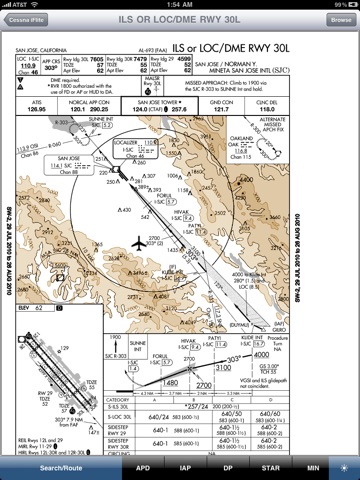
Cessna iFlite is an iPad application and requires a $139.95 annual subscription for full functionality. The initial purchase of 99c enables you to view A/FD and AOPA Directory information, to purchase and view Cessna POHs, and to have full access to the E6B. Viewing your aircrafts location on an approach chart requires a ChartData subscription with Seattle Avionics (not required to view charts or for SmartTaxi).
*** Now with ADS-B InFlight Moving Map Weather ***
Cessna iFlite feature set includes Weight and Balance, Takeoff and Landing Performance, and Aircraft POHs (additional purchase) for in-production single-engine Cessna aircraft including the Skycatcher, Skyhawk, Skylane, StationAir, Caravan, and Corvalis:
● Weight and Balance
● Takeoff and Landing Performance
● Aircraft POHs
GPS Information
● Compatible with internal GPS receiver, Bad Elf, Bluetooth GNS 5870 (or other Apple-approved GPS receiver), and the SkyRadars ADS-B Receiver.
Cessna iFlites tremendous feature set includes:
Multi-View GPS-Enabled Moving Map
● VFR Sectionals and IFR low/high enroute charts
● Overlay terrain onto enroute charts - see what is above you
● ADS-B InFlight Weather - NEXRAD, METARs, TAFs, AIRMETs, PIREPs, NOTAM-Ds.
● Displays Class B, C, and D Airspaces and Special Use Airspaces
● Airspaces Notifications
● SUAs and TFRs on the Moving Map -simply tap to get info.
● Adjust the Moving Map brightness easily
● Route CDI
● Direct-To option
● Impressive pinch-to-zoom
● Knots, MPH, km/h
A/FD, AOPA Directory, and Maps
● Comprehensive A/FD includes Airport, NavAids, and Fixes information.
● AOPA Directory includes FBOs, Attractions, Car Rentals, Hotels/Motels, Restaurants, Taxi Services, and Airport Diagrams.
● Includes Bahamas and Puerto Rico
● Integrated Maps and Yelp
Approach Charts
● SmartTaxi™
● The entire USA is stored on your iPad
● Easy to filter on All, ILS Only, GPS Only, or Six-Pack
● All charts are zoomable
● Print charts wirelessly
● Rotate DPs and STARs.
Wx Text
● Color-coded METARs, TAFs, winds/temperatures aloft
● Shows nearby airports with distance and direction
● Includes Alaska and Hawaii
● Celsius/Fahrenheit selectable
● Show/Hide RMK section
● Calculates METAR Density Altitude
● Calculates freezing level
Wx Images
● NOAA weather images include Animated RADAR, Satellite, Icing, Wind, Flight Conditions, Weather Forecast, Prog Charts, Lightning, and more
● Includes Alaska and Hawaii
Route Planning
● Enter identifiers including Victor Airways and Jetways
● Easily modify route by dragging to reorder
● Waypoints are automatically inserted in correct position
● Show Total and Longer Than Direct distances
● Flight Log shows Magnetic Headings, Groundspeed, ETE, Fuel Burn by using winds aloft information
● Optimize Altitude for winds aloft
DUATS
● Flight Plans and Weather Briefings downloaded using secure connection (optional) and are official and recorded by DUATS.com and can be reused for fast filing
● File, Close, and Cancel flight plans
● Obtain Weather Briefings - Route and Area
● Aircraft Manager auto-fills Tail, Type/Equipment, TAS, and Color fields of flight plan
● Part 135 friendly
TFRs
● Displayed on Moving Map
● Popup shows textual information
● Show Active or Pending TFRs (active within 24 hours)
E6B
● Conversions
● Distance-Speed-Time
● Pressure/Density Altitude
● Winds Aloft
● Runway Winds
● IFR Climb
● Descent Rate
Airport Status
● Show Airport Status at major airports
Documents
● FARs including Parts 1, 43, 61, 91, 119, 121, 135, 137, 141, NTSB 830, 1552, and 1562
● Parts of the AIM
● AC61-65E - Including Endorsements
● AC61-67C - Stall and Spin Awareness Training
● Pilot/Controller Glossary
● Aeronautical Contractions
● FSS Phone Numbers
Integrated Help System
● Built-in mini-manual
Note: Continued use of GPS running in the background can dramatically decrease battery life.


